The department is mandated to conserve and promote the sustainable use and management of Natural Resources and its environment. It encompasses Environment, Wetland management, Forestry and Land management (Physical Planning)
Physical Planning in its broadest sense refers to a set of actions aimed at improving the Physical, Social and Economic welfare of a place and its dwellers. It entails the organization of land uses so that people enjoy the highest achievable degree of efficiency in resource utilization, functionality of places and aesthetic quality.
STAFFS IN NATURAL RESOURCES
| S/N | POSITIONS | FILLED | VACANT |
| 01 | Senior Environment Officer | 0 | 1 |
| 02 | Senior Physical Planner | 0 | 1 |
| 03 | Environment Officer | 1 | 0 |
| 04 | Physical Planner | 1 | 0 |
| 05 | Lands Supervisor | 1 | 0 |
| 06 | Surveyor | 0 | 1 |
| Total | 3 | 3 | |
| Percentage of positions filled | 50% |
Apac Municipal Council Urban Pyhsical Development Plan-2020-202
LIST OF ABBREVIATIONS AND ACRONYMS
| CBD | Central Business District | |
| CBOs | Community Based Organisations | |
| CETP | Common Effluent Treatment Plant | |
| DEAP | District Environment Action Plan | |
| DWD | Directorate of Water Development | |
| EIA | Environmental Impact Assessment | |
| EMP | Environment Management Plan | |
| GIS | Geographical Information Systems | |
| GPS | Global Positioning System | |
| GoU | Government of Uganda | |
| MMC | Apac Municipal Council | |
| MTN | Mobile Telecommunication Network | |
| MoLG | Ministry of Local Government | |
| MoLHUD | Ministry of Land Housing and Urban Development | |
| NGOs | Non-Governmental Organizations | |
| M.C | Municipal Council | |
| UBC | Uganda Broadcasting Council | |
| UTL | Uganda Telecom Limited | |
| DWD | Directorate of Water Development | |
| NWSC | National Water Sewage Corporation | |
| RTK | Real Time Kinetic (GPS) | |
| GPS | Global Positioning System | |
| PC | Personal Computer | |
| USMID | Uganda Support to Municipal Infrastructure Development |
1. INTRODUCTION AND BACKGROUND
1.1 Background and Rationale to the Planning Activity
Apac Municipal Council highlighted key priority interventions in their Five-year Development Plan 2015/2016-2019/20120. The first among them is Physical Planning of the entire municipality. The rest of the interventions were also linked to physical planning. These include: Promoting good governance; Improving local revenue collection and administration; Solid and liquid waste management and sanitation infrastructural development; Construction of office block to accommodate all council staff; Good and regular maintenance of existing deteriorated access roads; Opening up new access roads; Extension of electricity to the council outskirts; Street lights; Acquisition of titles for all council lands; Mobilizing community to participate in development programs; and Operations and maintenance of infrastructure.
Apac Municipal Council undertook to review its physical development plan in accordance with Section 19 of the Physical Planning Act 2010 with aim to address some of the key development challenges, that include: haphazard development patterns in the Municipality characterized by unplanned and un-serviced settlements, poor accessibility and connectivity, and waste management problems. Others are widespread poverty due to un employment, Insensitivity on operation and maintenance of infrastructure and services; among others.
The challenges and opportunities for Apac municipality must be understood in this context – one where, currently, there is a gap between the provision of basic services and the rapid growth in the urban population. Enormous amounts of infrastructure are needed to support the ever-growing municipality and to support its population. Therefore, Apac municipal urban plan sets out the main direction for urban development over the next 10 years.
Setting the course for the Apac municipal council plan was in itself the starting point for integrated development, creating a better urban environment for everyone with central focus on conservation and preservation of environment, employment zones, accessibility, health, safety and security, among others. Thus, this plan creates value in every part of the municipality. The new Plan draws on the municipal’s Vision “A healthy prosperous society that is socially and economically independent by 2040” and mission “To serve the community through a coordinated delivery of services which focus on national and local priorities and promote the sustainable social and economic development of the Council”.
The vision means that wherever you live, you should be able to get to school or work due to high connectivity and accessibility, enjoy access to high-quality public institutions and facilities, public open spaces, parks and green spaces, and have public and commercial services available locally. The municipal vision and mission are in line with Uganda’s Vision, “A transformed Ugandan society from a peasant to a modern and prosperous country within 30 years”. This involves changing from a predominantly low income to a competitive upper middle-income country within 30 years.
Apac is an eccentric municipality, whose location and comparative advantage in the region provides it with potential for growth as an attractive and well-organized town. But that growth comes with a shared responsibility towards all the people who live there – a responsibility that should extend to future generations.
|
1.2 Purpose of Apac Physical Development Plan
Apac town is the main growth centre of economies, as well as being the growth centre of heterogenous populations and of the use of resources in the municipality. The planning philosophy in the preparation of Apac municipal plan is hinged on the municipality as the protagonist or the central character driving the growth in the north southern sub region with the aim to achieving a more sustainable future and enhanced quality of life among the populace.
Apac Municipal Council Physical Development Plan (Structure Plan) sets out the strategic planning framework for the development and use of land within the Municipality. It includes policies and proposals which provide the basis for the future growth and development of the Municipality with aim to: establishing a strategic planning framework for the future of Apac municipality from 2020 to 2030; Ensuring that this strategic planning framework supports and promotes the principles of sustainability; Giving broad guidance to local planning authorities in terms of the scale and distribution of new development and the provision of supportive physical and social infrastructure facilities and services; Guide the investment plans and programmes of those agencies and organizations whose activities support and service land uses; and Averting the upsurge of unplanned settlements in the Municipality, among others. As a municipality that has been in existence, good planning can provide the framework for making decisions that are resource effective and sustainable for all its four divisions.
1.3 Project Objectives
The primary objective of this consultancy was to prepare, review and update the Physical Development Plan (PDP 2018-2028) and a detailed plan for the Central Business District through a participatory process to guide the orderly and sustainable development of Apac Municipal Council.
1.3.1 Specific Objectives
- Review and prepare the Urban Physical Development Plan (PDP) that includes the spatial structure, land use and other associated layers for the Municipality, prepare planning proposals considering alternative planning scenarios (short term of 5 years, medium term of 10-15 years).
- Prepare a Local Physical Development Plan (Detailed Plan) for the Central Business District covering at least 4sq km. This should be agreed upon by the Client and stakeholders and should reflect critical need for the intervention.
- Develop an Investment Plan reflecting priority intervention areas for the short term (5 years), and a phased action plan with indicative costing for implementation of the identified projects within the Municipality over the medium and long term and also indicating the financial mobilization strategies
- Develop a communication strategy and engagement plan (Information, Education & Communication Strategy – IEC Strategy) for sensitizing the private and public stakeholders and conduct consultation workshops during the preparation of the PDPs.
- Develop plan implementation guidelines reflecting priority actions and development control guidelines for the implementation of the PDP and propose appropriate enforcement measures.
1.4 Project Tasks and Scope of Work
The tasks involved;
- Carry out a physical and natural ecological features study of Apac Municipal Council and its outlying region to determine the existing resource potentials.
- Undertake a Land-Use and Socio-economic studies with a view to proposing a policy/strategy for land use management.
- Prepare the necessary Base maps. These must be informed by accurate up-to-date spatial information obtained through verifiable appropriate methods such as topographic surveys, use of up-to-date satellite images and/or aerial photographs at appropriate resolution.
- Identify planning area; prepare Urban Physical Development Plan and Local Physical Development Plan proposals at appropriate scales (including their respective reports) in accordance with the National Land Use Policy of 2007 and the Physical Planning Act 2010.
- Develop a Strategic Plan to be used as a tool and basis for all major planning and development activities i.e. budget preparation and service delivery implementation to ensure that the Municipality’s resources are allocated in accordance with the Municipality’s vision.
- Develop and apply a simple, user-friendly strategy for effective popularization of the planning process and the subsequent plan and also disseminate related information.
- Clearly articulate the potentials for Local economic development of the Municipality, its comparative advantage and evolve priority interventions & strategies for development in the short, medium and long terms.
- Identify and document all informal settlements and land belonging to the council including existing markets with a view to re-planning and the improvement of the existing neighborhoods in Akere Division, Agulu Division, Arocha Division and Atik Division.
- Undertake, where necessary, mapping and digitization of topo cadastral features and natural resources of the town.
- Undertake an assessment of transport, infrastructure and utility needs, possibilities of dealing with existing roads in rapidly urbanizing nodes, housing and community services and propose new strategies. This will include mapping of the transport, infrastructure and utility network of the town.
- Prepare analysis reports and present proposals for future spatial, demographic, social and economic and industrial growth.
- Prepare a well phased out and costed Implementation Action Plan in the identified areas. It should have implementation schedule, planning and development policy guidelines and attendant resource and institutional requirements.
- Prepare attendant transport infrastructure services and community development facility plans.
- Detailed study of the CBD structure with view to decongesting and upgrading. – Provision of parking areas, Non-Motorized Transport (NMT) and pedestrian roads.
- Identify suitable land for both public purpose and utilities, recreational and address security issues in the town.
1.5 Previous Planning Interventions
In 2003 a detailed plan (LPDP) was developed by Habitat Consultants for the then Apac Town Council. The plan covered the Central Business District of the town.
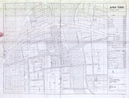
Figure 1: Apac Town Detailed Scheme;Source: Apac Municipal Archives – retrieved November 2018
The second plan, Apac Town Council Structure Plan 2006-2016 was prepared in 2006 by private Consultant – Delta Star Engineering Company. This plan expired in 2016 and since then the Town Council continued implementing the provisions of the expired plans.
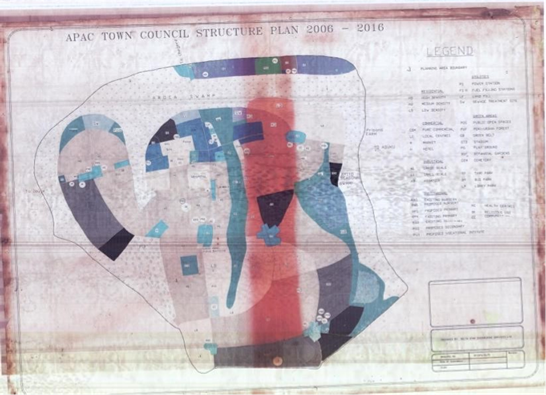
Figure 2: Apac Town Council Structure Plan 2006-2016
1.5.1 Key Reasons for the review of Apac Structure Plan
- The structure plan prepared in 2006 expired in 2016
- Municipality status came with several changes most especially adjustment in municipal and administrative boundaries.
- Growth dynamics – changes in the urban structure and spatial growth
- New investments in place requiring rezoning
The Planning Area
The history of Apac Municipal can be traced back to origin of Apac town which originated as a small nucleated settlement at the cross road from Lira to Masindi Port.
Apac municipal Council came into operation on 1st July 2016 after its elevation from Town Council status to municipality. The evolution of Apac as an administrative unit dates back to the era of the Colonial Administration in Northern Uganda during the first quarter of the 20th Century. Apac Town attracted more attention when a 104 Bed Hospital was constructed around 1968. This added to the already constructed semi-permanent Commercial Building and one Permanent County Centre built in 1964.
Following Administrative re-organization in 1974, Apac was made the District Headquarters of Western Lango District and was declared a planning area. Apac had not been growing fast enough despite those changes, this is simply because it lacked a significant economic base to stimulate and sustain its growth into a thriving economic and service Centre. Despite that fact, Apac Town still was the major Urban Centre in the District. Apac Town Council which was in Apac Sub County was then selected to be the Headquarter of Apac District. Basing on the central government move to create more Municipalities, strong lobbying by the leaders and the fact that it had not grown in status for over 30 years, Apac Town Council was then elevated into Apac Municipal Council (Apac Municipal Profile, 2017).
1.6.1 Geographical Location and Size of Apac Municipal
Apac Municipality is situated in the Northern part of Uganda between longitudes 32o West and 34o
East and latitudes 1.59o North and 3o South. It is approximately 280 km (direct) from Kampala via Masindi Port. The municipality is located within the Northern Uganda Economic Corridor (NUEC), an important and dynamic area with integrated networks of infrastructure within a geographical area designed to stimulate economic development. Apac Municipality has great potential for development, being an area endowed with fertile soils, by virtue of its location relative to the river Nile. Agriculture and agro based industry are some of the core economic activities that can be undertaken to stimulate development in the municipality. The Region has an economic advantage of being traversed by Masindi Port Road connecting to Lira, and hence will provide high speed links to the North and North Eastern Uganda. It is bordered by Apac Sub County to the East South and West, Chegere Sub County to the North and Ibuje Sub county to the North West.
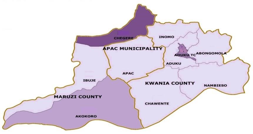
Figure 3: Location of Apac Municipality in Apac Distrcit; Source: UBOS
Administratively, the municipality is divided into four divisions, 20 wards and 97 cells/villages as in the table below:
Table 1: Administrative composition of Apac Municipal Council
| DIVISION | WARD | CELL |
| AGULU | 5 | 26 |
| AKERE | 4 | 22 |
| AROCHA | 7 | 32 |
| ATIK | 4 | 17 |
| TOTAL | 20 | 97 |
Source: Apac Municipal Profile 2017
1.6.2 Demographic information.
According to the 2014 population and Housing Census, Apac Municipal Council had a population of 50,962 with 26,014 females and 24,678 males. The population as per the divisions stands as below:
Table 2: Demographic composition of Apac Municipal Council
| Division | No. of households | Male | Female | Total |
| Agulu | 2,609 | 6,757 | 7,132 | 13,889 |
| Akere | 2,428 | 7,060 | 7,582 | 14,642 |
| Arocha | 2,134 | 5,257 | 5,489 | 10,746 |
| Atik | 2,006 | 5,604 | 5,811 | 11,415 |
| Total | 9,177 | 24,678 | 26,014 | 50,692 |
Source: UBOS cited in: Apac Municipal Profile 2017
The population growth as per original Apac Town Council is as below:
Table 3: Demographic Information of Apac Municipal for the last three years
| Year | 1991 | 2002 | 2009 projected | 2014 |
| No. of people | 7,216 | 10,137 | 12,500 | 50,692 |
Source: UBOS
The population increase has been attributed to the extension of the Town boundary to include some of the growth centers formerly in neighboring sub counties. Based on these statistics, the currents population of 2019 is calculated as below
Pf = Pc (1+r/100)^n
Where
Pf is the population projection
Pc is the current population
R is the population growth rate
And N is the time frame
So current population 2019
Is
Pf = 67585(1+3.5/100)^2
=72398 people in 2019
The proposed physical plan is slated to run for the next 10 years that’s from 2019 to 2029 So the projection by 2029
Will be
Pf = Pc (1+r/100) ^10
Pf = 72399(1+3.5/100) ^10, Therefore Pf =102,125 people.
1.6.2 Size, Relief and Natural Structure
The Municipality covers a total area of approximately 231.41 km2 of which 7%. is under permanent Arocha wetland. Apac Municipality generally stands at 3.540ft above sea level. The surrounding is the Northern Ugandan plateau consisting mainly of undulating flat land surfaces separated by wide permanent and/or seasonal swamps. The whole of Apac Municipality is drained by Arocha swamp flowing westwards into river Nile.
1.6.3 Climate
The climate is relatively warm with rainfall always well distributed from April to October, during which mean monthly rainfall exceeds 110mm. the main dry seasons are December – march with short dry spell in June. The peak rainfall months are May and August.
1.6.4 Soils
The soils are variable and are generally sandy clay and sandy loamy with low organic matter and low to medium nutrient availability.
1.6.5 Vegetation
The Natural vegetation of Apac Municipal and its immediate surroundings is moist cumbersome savanna mainly with scattered shrubs in the grassland, although some woodland also exists.
1.6.6 Land tenure systems
Land tenure system in Apac Municipal Council is of customary, freehold and leasehold type, with customary being dominant. There is personal attachment to land making land conflicts rampant. The women and youth who are the most productive have limited opportunity to influence land utilization.
1.7 Local Economic Development
Local economic development is an approach towards economic development where local people working together mobilize, manage and invest resources into economic ventures to stimulate and to achieve economic growth and development and to improve the quality of life. The people of Apac are engaged in small business enterprises especially retail shops and trade in agricultural and no agricultural products; food processing; food vending; and in transportation business in form of boda boda cycling. Increasingly the communities have set up organizations such as micro credit and lending groups. The Community Associations include: Lewic pemaki inyawawao, Opar can group, Catering service, Note ber group, Ateki-lwak association, Can pet yot womens group, Village and local savings, Youth livelihood project, APAC teachers sacco, Ont can group, Can apoto Atura, Acung ilwak, Atana youth link, Tecwao vsla, Teko en note vsla, Obanga en atwero, Barbek animal trackson (nusaf) and vsla, IBACO, Village saving and donar association, Lewic pmaka ingwello group, Devine listeners (disaster and preparedness), Can okema farmers group, Apur VSLA, and Can okoo nga, among others.
1.8 Municipal Sources of Revenue
There are majorly four sources of revenue for the municipality, these include: Local Revenues, Discretionary Government transfers, Conditional Government Transfers and Other Government
Transfers. The major sources of local revenues include among others: – Local Service Tax, Market/Gate charges, Application fee, Business licenses, Group registration, Inspection fees, Land Fees Sale of land Park Fees, Ground rent, Advertisement/Billboards.
Property rates will be introduced in the coming financial year.
Transfers from the central Government is of two types; Discretionary and Conditional.
Discretionary government transfers include urban unconditional grant (Wage), Urban Unconditional Grant (Non-Wage) and Urban Discretionary Development Equalization Grant. Conditional government transfers include Conditional Development Grant, Transitional Development grant, Sector conditional grant wage and sector conditional grant non-wage. Other government transfers include money for UWEP, YLP and other monies lobbied from the government.
Since Apac Municipal Council is new, it has not been able to attract donors but is working with
other development partners like the GIZ, International Life line funds. It is also under consideration for Uganda Support to Municipal Infrastructure Development (USMID).
2. APPROACH AND METHODOLOGY
2.1 Introduction
In ensuring the effective and efficient execution of the assignment, a three (3) stage approach was used; (i) Planning and inception, (ii) Field Work and Data collection, and (iii) Concept development and Plan production.